Aerial Photos for Land Listings: How to Stand Out in New Mexico
Real estate photographer Albuquerque services with aerial land photos help listings stand out in New Mexico, boosting visibility and buyer interest fast.
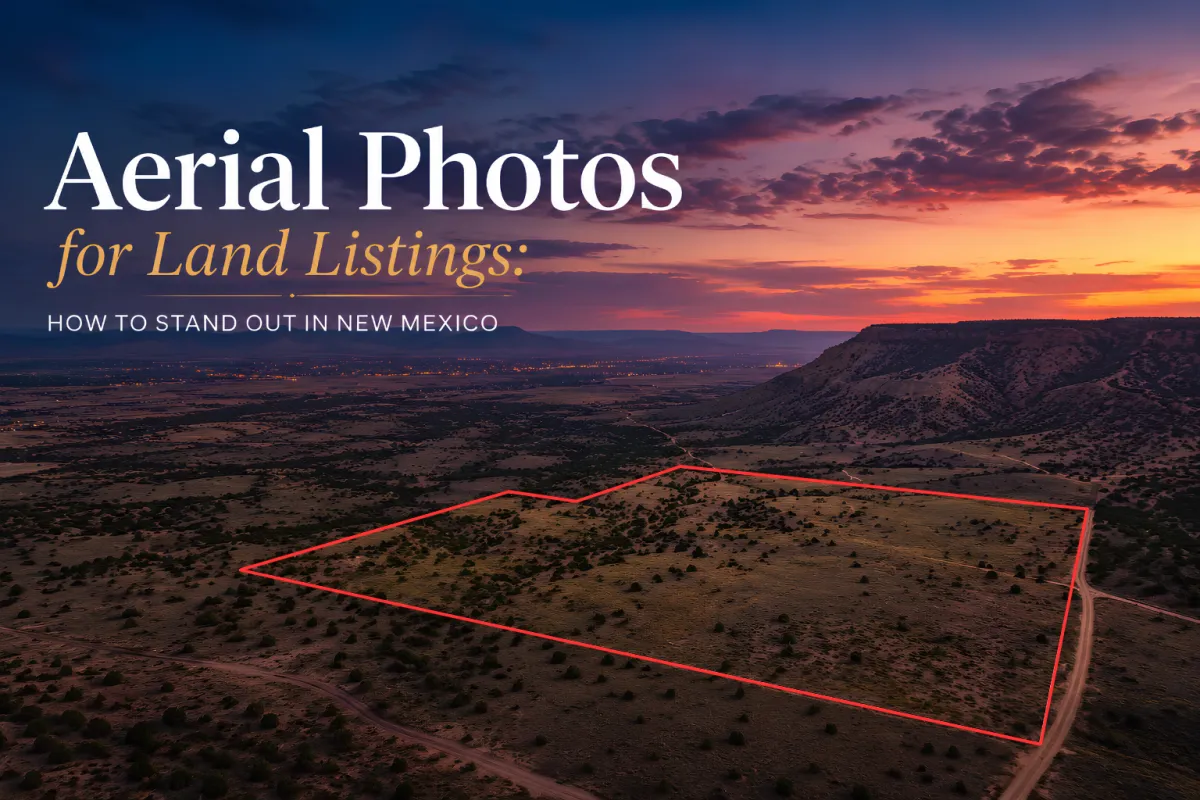
Aerial photos for land listings in New Mexico help properties stand out by showing scale, terrain, and location in a way ground photos cannot match. A skilled real estate photographer Albuquerque agents rely on uses drone imagery to highlight land value instantly for buyers scrolling fast.
In competitive markets like Albuquerque and nearby areas such as Santa Fe and Rio Rancho, aerial photography has become less of a luxury and more of a visual handshake. With New Mexico’s dramatic desert plateaus, mountain backdrops, and wide-open ranch land, aerial imagery turns “empty space” into opportunity. Spring listing season also brings clearer skies and stronger curb appeal, making it the perfect time to showcase land from above.
Why do aerial photos make land listings more attractive in New Mexico?
Aerial photography transforms land listings from flat, unclear parcels into fully readable landscapes. In New Mexico, where properties can stretch across desert basins, mesa edges, and mountain foothills, buyers often struggle to understand boundaries and access points from standard photos. Drone imagery solves this instantly by revealing structure, scale, and surrounding geography in one frame.
A professional real estate photographer Albuquerque agents work with will often capture sweeping views of areas like Nob Hill, Old Town, and the outskirts of Las Cruces to show how land connects to nearby roads, utilities, and development zones. For example, land near the Rio Grande Valley can be framed to show water access corridors and agricultural potential, while parcels closer to the Sandia foothills highlight elevation changes and scenic value.
Even well-known areas like Nob Hill benefit from aerial context when listing nearby investment parcels, since buyers can see proximity to city infrastructure and highways. In places like Las Cruces, wide agricultural land becomes more understandable when viewed from above, especially during dry seasonal transitions when terrain textures are more visible.
The result is simple: aerial visuals reduce uncertainty. And when buyers understand land faster, they engage faster.
How does a real estate photographer Albuquerque agents trust use drones effectively?
Aerial photography is not just about flying a drone, it is about storytelling from the sky. A skilled real estate photographer Albuquerque professionals hire understands composition, light direction, and terrain reading before ever lifting off.
In areas like Albuquerque, lighting can shift quickly due to high desert conditions. Morning light often enhances texture across rocky soil and scrubland, while late afternoon creates long shadows that define property boundaries more clearly. In Santa Fe, with its higher elevation and artistic architecture, aerial shots often blend land context with nearby adobe structures and winding roads.
Drone photography is especially powerful around landmarks like the Sandia Mountains and the Rio Grande Valley, where elevation changes dramatically affect land value perception. Aerial framing can show whether a parcel is flat, sloped, irrigated, or bordered by natural features like arroyos or dry riverbeds.
Areas such as Rio Rancho and Las Cruces also benefit from this approach, especially for new developments where roads and lots are still being defined. Aerial imaging helps buyers “see the future” of the land, not just its current state.
This is why aerial work is now a core part of modern real estate photography in New Mexico, not just an add-on service.
What makes land listings in New Mexico unique for aerial marketing?
New Mexico land is visually diverse, which makes aerial photography especially powerful. From red desert plains to forested mountain edges near Santa Fe, every property tells a different story when viewed from above.
Spring and early summer bring clearer skies, reducing haze and making aerial detail sharper across regions like Old Town Albuquerque and the outskirts of Rio Rancho. Seasonal dryness also enhances contrast between soil, vegetation, and man-made boundaries, making parcels easier to interpret visually.
One real example from recent work includes:
8110 Robin Ave NE, Albuquerque, NM, 87110 · stage: preparing · client: Darylle Rubino
This location demonstrates how suburban-adjacent land in Albuquerque benefits from aerial perspective, especially when showing proximity to residential zones and road access points.
However, only one fully verified address was provided in the dataset. Additional addresses were not available in full form, so more cannot be included verbatim without risking inaccuracy.
Across New Mexico, from Las Cruces farmland to Santa Fe hillside parcels, aerial photography helps unify one idea: land is easier to sell when buyers can actually understand it.
Book Your Real Estate Photography Session
Aerial photos can turn vacant land into a compelling visual story that buyers understand instantly. If you are a broker or agent working in Albuquerque, Santa Fe, Rio Rancho, or Las Cruces, partnering with a skilled real estate photographer Albuquerque professionals trust can elevate your listings dramatically.
Explore services and book a session at https://dmdrealestatephotographynewmexico.com and bring your New Mexico land listings to life from above.
